Climate Crisis: Report on Climate Change and Real Estate Shows the Most Dangerous and Safest Areas for Real Estate
Put together by the team at Clever Real Estate
Climate change will have a huge impact on the U.S over the course of the 21st century. That impact, especially in economic terms, may be even more profound than we realize.
Climate change will affect different areas of the country to varying degrees because of geographic and climate differences. Some places may experience small changes, while others might be devastated by extreme flooding, wildfires, and heat.
Unfortunately, a new study on climate change from Home Bay shows that the most densely populated areas with the most valuable real estate are the most vulnerable to the destructive effects of climate change. In other words, the U.S. isn’t prepared for the coming adversity.
Extreme Weather Is Becoming More Common and More Costly

The U.S. has always experienced extreme weather events, but the frequency of those events has skyrocketed. Adjusting for inflation, the number of billion-dollar weather disasters occuring year-over-year has increased a stunning 567% since 1980. Over that span of time, natural disasters have cost the U.S. more than $2 trillion.
Between 1980 and 2007, the U.S. averaged 4.7 billion-dollar disasters per year. Since 2008, it’s averaged 13.6 per year, adjusting for inflation. And in 2020 and 2021, it’s averaged a staggering 21 per year.
The most costly of all natural disasters is the hurricane, which causes $20 billion in damage, on average, per storm. More than half of the $2 trillion in extreme weather damage that has occurred in the U.S. since 1980 was the result of hurricanes.
It’s no surprise, then, that the hurricane-prone Gulf Coast has absorbed the most economic damage in the past 42 years. Since 1980, Texas, Louisiana, and Florida have each taken more than $250 billion in weather-related damage.
Texas has been especially hard hit. Since 2012, the Lone Star State has been impacted by 73 separate billion-dollar disasters, making up just over half the nationwide total over that time.
Disaster-Prone Areas Have Seen the Largest Increase in Home Prices

It seems reasonable that homes in areas prone to extreme weather would decrease in value as fearful owners sell their homes, insurance companies stop offering coverage, and wary buyers stay away.
But in the U. S. housing market, the exact opposite has happened.
Since 2012, metro areas in the three states with the most Federal Emergency Management Agency-declared disasters have seen average home prices far outpace the U.S. median home price. Home prices in those states — California, Oregon, and Washington — have jumped an average of 167%, compared to the nationwide increase of 113%.
California tops the list, recording 146 FEMA-declared weather and environmental disasters since 2012 — 564% more than the average state. Yet the Golden State is also home to some of the hottest housing markets in the country.

Even as the state faces existential threats from wildfires and droughts, home prices have increased by 190% in San Jose, 183% in Riverside, and 147% in Los Angeles.
In fact, when FEMA calculated Expected Annual Loss (EAL) scores for each state, quantifying potential risk and loss by assigning each state a rating between 0 and 100, California topped the list with a maximum of 100. Texas was a close second (86), followed by Florida (57.3), Louisiana (48.1), and North Carolina (48.1).
That California is exposed to twice the risk as Louisiana, a state that’s eroding into the Gulf of Mexico at a terrifying pace, should give potential California home buyers serious second thoughts.

The Most Dangerous Places for Wildfires
In 2021, nearly one-third (31%) of all U.S. land impacted by fire was in California. Like the rest of the country, the Golden State has seen a sharp rise in extreme weather events. The eight largest fires in California history have all happened since 2017, and five of the six largest occurred in 2020 or 2021.
The California counties most vulnerable to wildfire are Riverside, Los Angeles, and San Bernardino counties. As noted above, Riverside and Los Angeles counties have seen astronomical increases in home values.
Of the 50 most-populated metro areas in the United States,15 are in states with high wildfire risk — a fire-specific EAL score over 50. Six of those metros are in California, four in Florida, four in Texas, and one in Arizona.
Median home prices in those metros have increased by 166% since 2012, compared to 113% nationwide. In fact, metros that were vulnerable to wildfires saw home price increases larger than metros vulnerable to other types of natural disasters.
What’s causing this strange correlation? Hot, dry conditions conducive to fires also attract home buyers. Other home buyers may not realize the risk when they buy in these areas.

The Most Dangerous Places for Hurricanes
Hurricanes are by far the most costly and destructive natural disaster. With a hurricane-specific EAL score of 100,Texas is the most vulnerable state when it comes to hurricanes. Other vulnerable states include Florida (78.5), Louisiana (68.8), North Carolina (62.7), and Mississippi (54.8).
Home prices in hurricane-prone metros have far outpaced national home prices, rising 139%, compared to 113% nationally.
Vulnerability to hurricanes depends on having coastline, so it’s understandable why these states have such valuable real estate. Many people may own vacation homes there or operate rentals to make passive income.

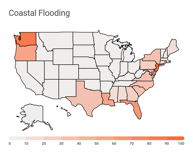
The Most Dangerous Places for Flooding
When it comes to coastal flooding, New Jersey has a 100 EAL score, indicating extremely high risk. Second on the list is Washington state, followed by Florida, Oregon, and Louisiana.
Home prices in those states have risen 153% over the past decade, once again outpacing the national rise of 113%.
Interestingly, homes in metros prone to river flooding, as opposed to coastal flooding, have actually lagged behind the national average — rising only 99%, compared to 113% nationally. Whether that’s because real estate along rivers is simply less valuable than coastal real estate — or if there’s something uniquely repellent about river flooding — is up for debate.
Where Are the Safe Havens?
Nowhere is completely insulated from climate change, but there are places where its effects will be attenuated. Most of those places are in the Northeast.
The state with the lowest overall EAL score is Rhode Island, with a minuscule 0.2. Second is Vermont (2.7), followed by Delaware (4.6), New Hampshire (6), and Maine (8).
The states with the lowest wildfire risk are Alaska, Hawaii, and Indiana. The states with the lowest risk of river flooding are Alaska, Idaho, and Delaware.
Just like the most expensive housing markets are found in the riskiest locations, markets that have experienced the smallest home value increases since 2012 are overwhelmingly located in the safest states.
At the top of this list are Hartford, Connecticut; Baltimore; Virginia Beach, Virginia; and Milwaukee. They have all seen home price increases less than 50% over the past 10 years — compared to 113% nationally — and are in states with EAL scores less than 27.
Key Takeaways on Climate Change and Real Estate
For now, at least, some of the biggest housing bargains, especially for those buying a home for the first time, are also found in states that will be least impacted by climate change over the next several decades. As extreme weather continues to accelerate, these deals may not last. Buyers thinking long term should buy now.